
Throw a dart at a list of America’s urban waterways, and you’ll likely hit one that has been undergoing redevelopment — often for some time. On the West Coast, Portland, OR’s Downtown Waterfront Urban Renewal Area plan for the Willamette River, started back in 1977, is still going strong. On the East Coast, the Richmond Riverfront Plan, approved in 2012, aims to revitalize 2.25 miles of the James, in Virginia, over approximately 20 years. In between, additional extensive waterway initiatives are under way in San Antonio, Fort Worth, Chicago, Minneapolis, and Pittsburgh, among others.
Bill Wenk has been involved with a number of these popular riverfront reclamation projects that have cropped up over the past few decades. His Denver-based landscape architecture firm, Wenk Associates, has tackled revitalization along the Milwaukee and the Platte, in his hometown, among others, and always they are long-term projects, due to both their sheer enormity and the number of stakeholders involved.
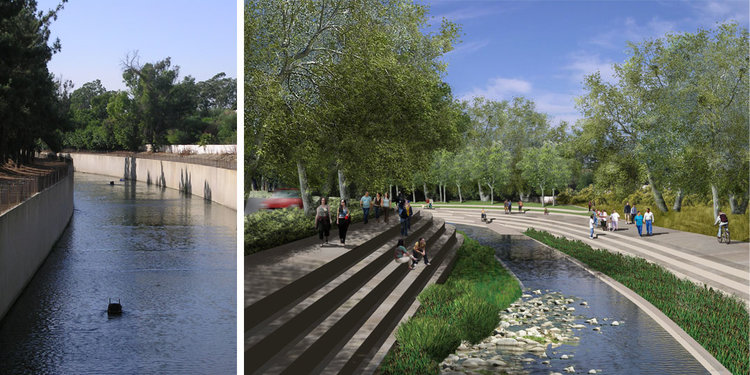
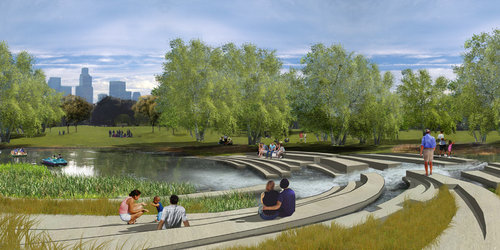
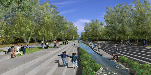
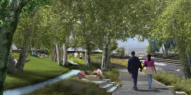
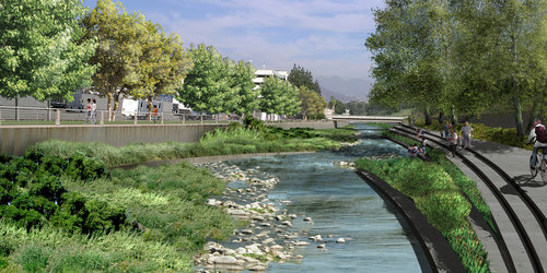
Five years ago, Wenk Associates joined a multidisciplinary team to work on one of the biggest river projects yet: a multidecade master plan to transform approximately 32 miles of the concrete-lined Los Angeles River back into a natural waterway, with dense vegetation, pedestrian paths and bridges, and a controlled flow. Last week, Wenk sat down with BuiltWorlds to discuss the benefits and challenges of large-scale riverfront renewal, detail his firm’s involvement with the LA River Revitalization Master Plan, and parse out the project’s particular complications.
Why do you think so many cities have taken on riverfront redevelopment recently?
First of all, most waterways — LA’s an exception, in part — rely on industrial uses, and a lot of that industrial use has gone elsewhere. So, you have thousands of acres of derelict land that was just begging for a new use.
Looking at how we might revitalize our cities is the second part of it. Once pollutants were dealt with — sewage, mostly, and industrial discharges — the rivers got a lot cleaner, so they started to be attractive, just by their intrinsic qualities. Cities see them as being economic drivers anymore, as amenities that can really jump-start revitalization.
You’re firm has worked on a number of urban waterways. What’s the most common problem you’ve seen with such waterways before you’ve stepped in?
They’re so constrained. They usually have things channelized and filled to the point that they don’t have enough capacity for flood control, so the surroundings are often flood-prone. And development and private ownership really limits what you can do easily. They’re barely natural in many senses of the word.
For example, the base flow of the LA River — it’s sewage discharge, treated, that is really the flow. So, it being natural is quite a stretch, ignoring the fact that it’s concrete-lined. You get this really screwed-up river hydrology because of urbanization, and then you get the corridor being confined by urban development.
What landscaping challenges does the confinement present?
Flood control. Capacity becomes one of the central drivers, and then habitat, some sense of a working ecology, of a functioning natural system. With the LA River, the goal was to bring steelhead trout back upstream to spawn, and there’s a warm-water minnow, a species of concern, that is driving some of the thinking about improvements to the South Platte. How that integrates with the fluvial hydrology or the hydraulics of the river becomes really important. It’s really more of a landscape restoration strategy.
What were the specific design challenges of the LA River revitalization plan?
The LA River was a brilliant piece of engineering when they concrete-lined it, because the engineers figured out how to move vast volumes of water very quickly through the city. In doing so, it just destroyed the natural system that was the river, and any sort of seeming recreational or ecological quality was lost.
The city built up right against it, and you can’t remove the city. To literally restore the LA River to what it was, you’d have to create a corridor that’s a half-mile wide, at least. The LA River is, depending on where you are, a couple hundred feet to close to 1,000 feet wide at its mouth, so you have to work within that existing concrete trapezoid. And the velocities of the river during a major flood event are upwards of 30 feet per second. You see waves that are 20 feet high. It’s a raging torrent.
It’s designed that way to carry as much water as possible. The problem with taking the concrete out is that it increases what the engineers call the roughness coefficient and slows the water down, and as soon as you slow the water down, it floods the surrounding areas. So, you have to figure out how to store water upstream to reduce the volume, and that is an enormously complicated and expensive effort that will take generations.
What did you propose to overcome the challenges?
One, increase the capacity of existing storage areas. There are large debris basins that store water now during major floods. For example, there’s Sepulveda Basin: 1,000-plus acres of recreational facilities in the San Fernando Valley. That could be deepened by 10 feet to reduce the volume, and the scale of that [project would be] enormous, but over time you could actually do that.
Second, you can use green-infrastructure approaches — rather than traditional gray storm-water piping approaches — to storm-water management. So, you’re storing water all over the basin, and by doing so you reduce the volumes. But this would be many generations down the road, to do that. That’s how you store water.
The nice thing about portions of the river is that they have soft bottoms, so the [major-flood] velocity has to drop to 12 or 13 feet per second. At that rate, you can start to revegetate without increasing the size of the river channel itself. And in those portions, you can start to take out the concrete. That’s really the first phase is those areas that have the soft bottom.
“LA County owns the concrete of the river, the Army Corps of Engineers administers the river, the city owns the water, and the environmental organizations act as cops. Everybody’s got an interest in the river.”
Is it challenging working on land that’s been so heavily developed?
Oh, yeah. Quite often you get development that has encroached on the river. A good example of that on the LA River is Studio City. It’s in the San Fernando Valley, it’s where movies are made — have been for three generations, four generations — and it’s really an industrial area that has grown right up against the river, and it has vertical walls on it, and it may be generations before it changes. You have to learn how to work with and look very long-term at phased implementation of a very long-term vision, which is really what the LA River master plan is. It’s a 50-year plan, a 60-year plan, in my mind, and I think the city acknowledges that.
What about in the downtown area of LA? Did that present any particular challenges?
Well, in the downtown, it’s lined by railroads, transmission lines, power lines. To say it’s hemmed in is an understatement. Because of those major utility corridors, just getting to the river is a challenge. It has very large industrial areas, too, and some of them are still pretty healthy and actively used, and you certainly don’t want to change land use if it’s contributing to the vitality of the city. It really varies depending on where you are.
Do you end up encountering community resistance ever?
In LA, the issue is one of gentrification. There are a couple of neighborhoods along the LA River very close to downtown LA, they have a certain charm, and all of a sudden people discover them and there’s displacement.
An exception to that was when I worked in Milwaukee, where the neighborhoods were isolated from the river valley and the redevelopment brought in job-rich businesses that actually brought jobs back to the neighborhoods in the valley.
There were a lot of parties and partners involved in the LA River master plan. How did your work fit with theirs?
LA County owns the concrete of the river, the Army Corps of Engineers administers the river, the city owns the water, and the environmental organizations act as cops. Everybody’s got an interest in the river.
Tetra Tech was program manager, and they did the engineering. My firm was the principal river planner. Another Denver firm, Civitas, was urban design, because what happens along the river is as critical as the river itself.
We really collaborated with the engineer to bring [the river corridor] together in a creative way. I like to say I know enough about engineering principles to be dangerous, to really have a discussion with the engineer and push back on single-purpose engineering solutions.
What benefits does a city see from urban waterway renewal?
Jobs, recreation, and improved water quality — and environmental education. On the Platte River, in Denver, there are some old industrial neighborhoods that probably have the hottest real estate in the city right now. The prices have gone from under $10 a square foot for land ten years ago to land prices that are greater than land prices in the downtown of Denver. And Denver’s a pretty vital city with a healthy city core. The river is seen as being a real amenity.
So it really tends to draw people back.
Yes, and I know that’s happening in LA. A lot of developers are buying property and buildings. It’s a long-term investment.

Discussion
Be the first to leave a comment.
You must be a member of the BuiltWorlds community to join the discussion.