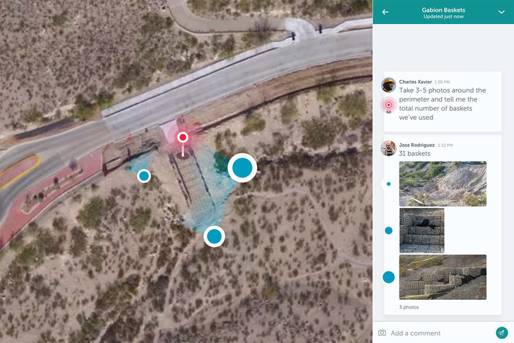

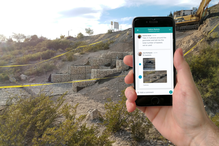
Unearth Labs wants to help keep everyone on the same page. The company’s cofounder and CEO, Brian Saab, describes its software as “Slack meets Google Earth,” and the basic idea is to give everyone involved with a project a platform through which to share all information and make critical decisions. The tool combines aerial imaging with on-the-ground data from sensors and smart phones to provide a comprehensive overview of what’s happening and where on any project, and it allows individual stakeholders to talk to each other and respond to queries and concerns in real time, either from the office or the job site.
Saab sat with us for a conversation about how he arrived in the construction space after pursuing other software ventures, how his current software differentiates itself from other communication and information-sharing tools in AEC industry, and what features he hopes to add to it in the future.
Your LinkedIn profile showed a lot of different software companies. How many other start-ups were you a part of before Unearth Labs?
I moved with my family to Seattle a little over ten years ago. I joined Microsoft and met some incredible people, and after a pretty good tenure there, I left, and a couple of guys and myself started a digital agency. We were basically doing software development on behalf of media companies like CBS and Disney and NBC, taking their media properties and putting them into native applications on mobile devices.
Then we started a marketing automation platform for hotels. That was our second start-up. We built that from about 2010 to 2014, ended up with offices outside the US. That got acquired by the Priceline Group, and I spent some time working on integration within their Booking.com division.
I left in September 2015, took some time off, started to think about what would be my next project, and that is what ultimately led to the formation of Unearth.
What was behind your decision to suddenly move into the construction field?
When I was thinking about what was going to be next, I really started from the angle of IoT, robotics, remote sensing. That entire category caught my attention. I’d spent so much time focused on software, [not] the combination of hardware and software—particularly hardware that could be commoditized to the point that you could put it out in the real world and not worry about it the way we traditionally worried about expensive hardware out in the real world, even as recently as five years ago.
So the hardware led you to construction?
I ended up talking to a lot of different industries about things like remote sensing or computer vision. Construction just kept popping up as an industry that could take advantage of the technology, had real need around what the technology could provide. And, you could answer the question “Why now?” There seems to be a shift in the industry to adopting technology and trying to use it to drive productivity improvements or drive revenue or create cost savings.
Then, a little more personal to me, my family is in the construction business. My father is a builder, a land developer, and a general contractor; my grandfather was a developer as well. It gave me a great opportunity to align with them and just discover what it is they do on a day-to-day basis. I could show up as the technology expert and then humbly ask, “Would you use this?”
Talk about what Unearth Lab’s software is meant to do.
The simple way to think about it is, we’re creating Slack-meets-Google Earth for construction. We are really focused on trying to bridge the gap in communication between field and office.
Drones and the Internet of Things are mentioned on your site as well. Where do they come into play?
The software takes data inputs from breadth and depth, so we use drones but we also use satellite imaging, we use aircraft imaging. We’re agnostic when it comes to where that aerial imaging comes from, but we use it to set context as to what’s happening on a particular job site at a particular point in time, which then becomes the backdrop for all the conversation and decision-making [between] stakeholders that are on the job site or in an office somewhere.
We also gather more precision-based data from the ground. Something as simple as photography from a smartphone or a tablet or IoT sensors that are sending data. Obviously, telemetry from heavy equipment, all the telematics stuff. We’ll gather all that; it’s a heterogeneous data environment.
It really takes capturing both breadth information as well as more precision-based observations on the ground—then allowing the experts, whomever they might be, to have conversations and decisions against that data.
So at first I had the impression you were creating project-management software, but it sounds a little different than that. Who are your competitors? How are you differentiating yourself from them?
When we first took a look at the industry, we saw some interesting camps. Certainly there’s a lot of innovation we’ve seen around taking a pen-and-paper process and turning that into some sort of digital process. There’s some great examples around project management—as well as accounting or enterprise resource planning—that already exist within the industry and have really revolutionized how those manual processes are handled today.
The other camps are more along the cutting-edge: things like remote sensing, things like drones. But, they end up being locked into that paradigm. When we look at just aerial imaging companies, they hang their hat on the drone itself as the solution. They may have a drone, they may have software, but that’s the limits of their sandbox.
We came in as outsiders, not really knowing construction, observing what was happening with multiple projects we were partnered on. What we saw is it really took both. It took imaging from a drone—or you might be able to get off-the-shelf imaging from satellite or aircraft—and that helps you answer some of your questions, but then you have to marry that with other information coming from somewhere else. It’s the combination of the data that starts to give you a really complete picture.
And what did you want to do with this holistic set of data?
That complete picture was not something that we then wanted to put into a Gantt chart or some sort of project-management tool. Rather, it was just there to stimulate conversation between the decision-makers, whether that be a project manager and a superintendent or a foreman reporting back up to a superintendent [or] an outside inspector identifying issues that need to pass back to the general contractor.
It was capturing all that information together and allowing the right people to discuss what they were seeing. So, [it’s] not project management in the traditional sense; it was more about digitizing what we were actually just seeing out on the job site, democratizing that data, and getting it into all the hands of the people that need to make a decision.
How far along is your software in development? Do you have clients already?
We started formal engineering on the platform last October. [We shipped] our minimum viable product [in late April], which we’re very excited about, and that’s really been a combination of an aggressive engineering effort on our part and some great partnerships we’ve had with contractors here in Washington and down in Texas.
What’s been interesting is that we really focused on working with contractors, but we’ve also been opportunistically pulled into some other opportunities. Like any start-up, you start to discover new customers, so we’re working with some refineries in the Midwest. These are fixed assets; they’re more in an operations-and-maintenance mode. Our software’s being used to monitor those assets and help connect ownership teams that are in Connecticut with the actual facilities folks in the Midwest.
Can you talk about any of the contractors you’re already working with?
I can tell you that we’re working with contractors that range from $20 million a year in revenue to $2 billion a year in revenue. I would imagine if I named them you would know them.
“We’re creating Slack-meets-Google Earth for construction. We are really focused on trying to bridge the gap in communication between field and office.
You’ve already raised some funding for this project, too. Who are some of your bigger backers, and about how much have they given?
We’ve raised a nominal seed round: $1.6 million back in the end of last year. Truthfully, those investments are angel investors here in the Pacific Northwest. That’s really a reflection of myself and my cofounder’s personal network, based on some of the prior start-ups we’ve done in the area.
It’s an angel-investment crew, not an institutional investor or a VC investor or something like that. That’s probably a successive round that we’ll put together later this year or early next year.
Are there features you’re hoping to add to your software in the future?
Boy, if you could see our whiteboard. We’ve had incredible feedback from the contractors and owners we’re working with now, and our product roadmap has grown beyond our initial vision. I think we’re heading toward several initial processes around predictive identification of what we’re seeing from data coming in. Again, sort of a key aspect of our platform is that we have this mixed, rich data set coming in—both at a high, aerial level and a ground level—which is really training our software to see what people see and then become predictive.
We’re going to continue to double down on the true collaboration and communication aspects, and it will ultimately also drive us to seek integration. I come from the technology world, I love open data, I love having a rich ecosystem of software that adds value, and we want to play a part in that. We’re already getting pushed by our customers to integrate our software. So, you’ll start to see that as well. We’ll be looking to push whatever data we have on our platform to other platforms.
Discussion
Be the first to leave a comment.
You must be a member of the BuiltWorlds community to join the discussion.